Geo-Surface Canada Edition
Free LiDAR Elevation Viewer & Terrain Mapping Tool for CanadaInstantly explore Canada’s topography with our free online elevation map. Simply click anywhere in Canada to view precise elevation data—1–2 m resolution in LiDAR-covered regions and 30 m resolution elsewhere.
-
Toggle LiDAR Coverage: Enable the LiDAR Terrain layer in the Base Layer dropdown to see where high-resolution data is available.
-
Build High-Definition Terrain Overlays: Click Build Elevation Map, draw your area of interest, and generate a stunning 3D-style terrain image.
-
Flexible Area Sizes: Map anything from a single quarter-section to vast landscapes. Smaller areas reveal subtle elevation changes and terrain details; larger areas provide broad, interactive overviews.
Start your elevation analysis now—no signup required. Harness Canada’s best free LiDAR elevation viewer or go Pro to uncover every ridge, depression, and flow route in seconds. Runs on all devices, but works best on bigger screens!
Looking for More Features? Upgrade to Geo-Surface Professional
Geo-Surface Pro is built for power users who need more than just elevation.
It adds advanced drainage mapping layers, full drainage design tools, and support for importing and exporting data and map files—all in the same easy-to-use web browser interface as the free version.
You get features that normally cost thousands in desktop software—for just $499/year per region (currently available regions are US and Canada).
Map Fields or Entire Regions—Up to 1 Million Acres at a Time
Generate Advanced Drainage Layers, Elevation Profiles, and Design Drainage Systems for Any Land Area—Big or Small
Wherever LiDAR elevation coverage is available (that's virtually all of the U.S. and expanding areas of Canada), simply draw around a field, property, or custom area of interest to create multiple high-resolution drainage mapping layers in under 2 minutes.
🚀 Now supporting areas up to one million acres at a time!
Map massive regions in a single request. Capture major flow routes, significant slopes, key depression zones, and general wetness potential areas over massive areas all in your web browser with a few clicks. Export generated layers for further analysis in GIS software.
For field-level mapping (quarter sections, sections, or custom-sized fields), Geo-Surface delivers highly detailed, high-resolution outputs—showing flow paths, depressions, slope variations, and wetness potential down to partial-acre precision.
Whether you're mapping 80 acres or 800,000, Geo-Surface scales to your needs—giving you the critical terrain insights to plan projects, manage drainage and water, and identify key terrain and relief features like never before.
Surface Drainage Design Targeting depressions and highest value wetness potential areas
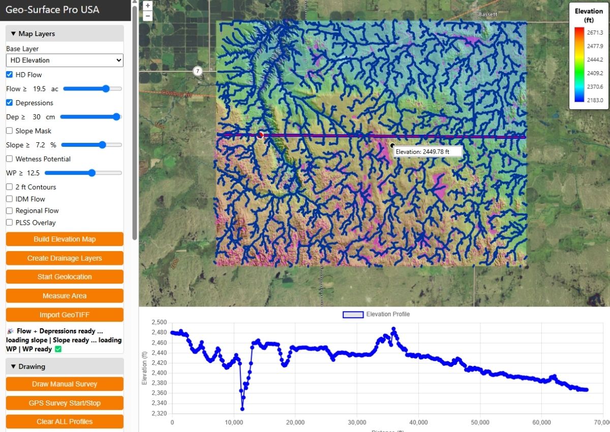
80,000 acre project region with terrain, flow, depressions, and cross section profile
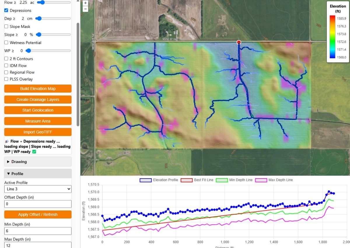
Half section flow routes show optimum drain paths to fix depressions
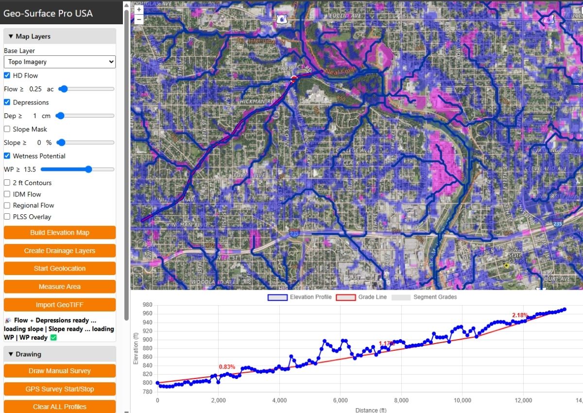
Identifying major flow routes, depressions, wetness prone areas of Des Moines, Iowa
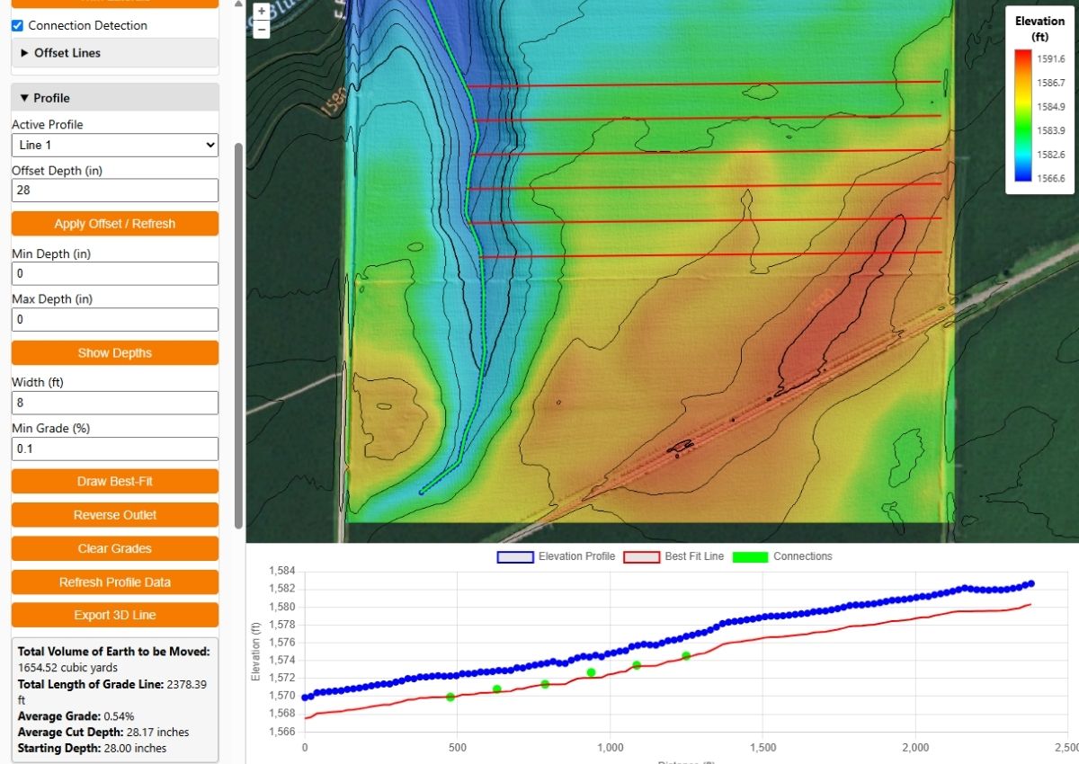
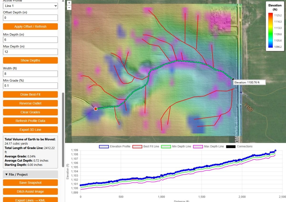
Creating a Tile Drainage Design with Connection Validation
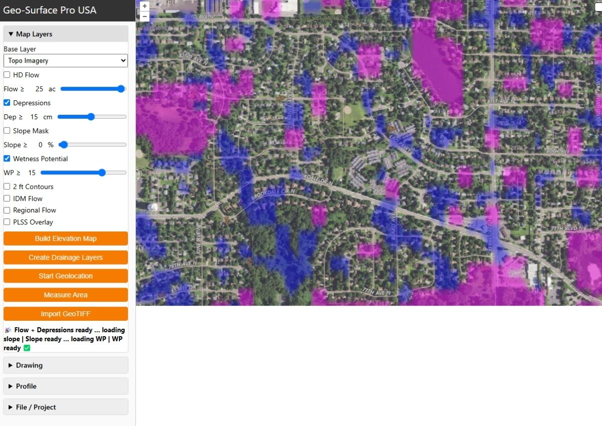
Wetness Potential and Depression Mapping of residential areas in Minneapolis
On-Demand Drainage Flow Mapping
At any location with LiDAR elevation coverage (that's all of the US and these areas for Canada), drawing around a field or land area AOI allows you to automatically generate multiple advanced drainage mapping layers.
NOW YOU CAN MAP UP TO ONE MILLION ACRES AT A TIME!
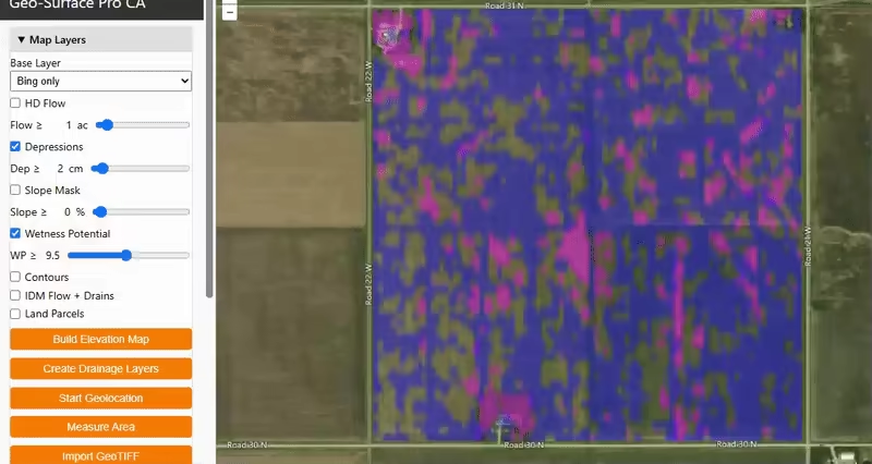
HD Flow is a high-resolution flow mapping layer that shows you exactly how water moves over the land. This is your secret weapon for effective drainage planning! Adjusting the slider let's you see how many acres drain to each flow route segment at the field level, easily identifying not only the best drain placement routes, but also where the most important drains are. On larger regions, you'll see major flow paths, and you can always export the computed flow in KML for deeper anaylsis in GIS software.
Field Depression Mapping
The Depressions map layer (created at the same time as HD Flow) shows you depressional areas within the field or landscape. These are sinks, or low-lying areas that have no natural drainage. Using the on-screen slider, you can adjust the view to see only deeper depressions as required, up to 30cm / ~1ft (export to your GIS software for more detailed analysis). When combined with the HD Flow map, this is often all that is required to export into grade control software like Ditch Assist™ to show you exactly where to make your drains for the most effective surface drainage - remember, whatever you see on the map you can export that view and overlay it on the map in Ditch Assist!

Slope Mask Layer
As you move the slider for the Slope Mask layer, the first areas that become transparent are the flattest parts of the field or project area. As you continue advancing, you'll be left with only the steepest slope regions highlighted. In addition to helping you identify steep areas with high erosion potentials and the best sites for grassed waterways, this layer can also be used to identify the most level sites within an area for future construction and other projects. And, like all the other generated layers, it can be exported for further anaylisis in GIS software when required.
Wetness Potential Mapping
Wetness Potential shows you the areas that are most prone to waterlogging, but not necessarily classified as depressions. When moving the slider from right to left, the first areas highlighted are likely the first that will become waterlogged based on flow and slope characteristics of the land. Wetness potential helps you identify parts of the field that may require more effective drainage, and can be particularly useful when designing tile drainage systems to help identify which areas might require tighter tile spacings.
Users are also applying wetness and depression mapping in residential areas, helping identify homes built on moisture-prone terrain—often linked to basement water issues.
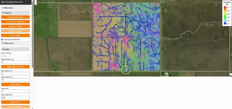
Advanced Drainage Design Tools
Geo-Surface Pro delivers advanced surface and tile drainage design tools—just like high-end desktop software, but in your browser.
Draw or GPS a proposed drain route to instantly view the terrain profile. Add a best-fit or constant-grade line to simulate how your machine control will perform in the field.
See estimated start depths, cubic yards to move, and check grades at a glance. Use connection validation to ensure every lateral joins the main correctly—whether it’s tile or surface drainage.
Go to the field with a plan—not a guess.
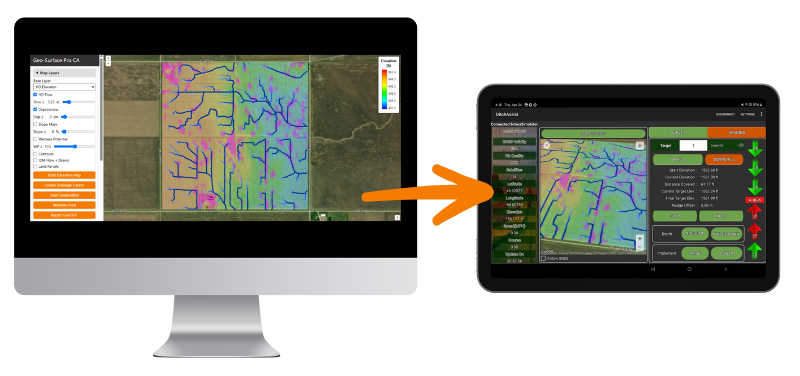
Export What You See, Use It Where You Need
Geo-Surface Pro runs entirely in your web browser, so it works seamlessly on any device.
Design drainage systems on your PC or Mac, then open the same project on your phone or tablet in the field—where built-in geolocation helps you follow and stake out your runs with precision.
Easily save and resume drainage design projects anytime.
Need a quick reference layer? Instantly export map images showing whatever’s on your screen—including flow routes, elevation, or design lines—perfect for importing into Ditch Assist™ or other mapping tools.
Works with QGIS, ArcGIS, Google Earth & More
With Geo-Surface Pro, your data is yours to keep.
Need the LiDAR you're viewing in QGIS or ArcGIS? Just one click and it’s downloaded to your hard drive. Export flow routes as KML files—ready for use in any GIS software or for easy viewing in Google Earth or Google Earth Pro. Want to import your depressions layer into QGIS? No problem, just save it to your hard drive! Likewise with the slope and wetness potential layers you generate. It's your data, you own it!
And we’re constantly expanding what you can generate and export, with new layers and features added regularly.

From Flow Mapping to Full Design and Data Export—It’s All in Pro
$499/year
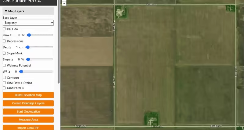
🧭 Geo-Surface Canada: Free LiDAR Elevation Viewer & Mapping Tool for Any Field or Property
Explore Elevation Across Canada Instantly — No Sign-Up, No Downloads.
Geo-Surface Canada lets you click anywhere on the map to instantly view precise elevation, powered by high-resolution LiDAR data where available and medium-resolution models elsewhere. Whether you’re a farmer, landowner, consultant, or planner, this free tool puts powerful Canadian elevation mapping at your fingertips.
📍 See Farm Elevations Instantly
With a single click, view the elevation at any location in Canada. Quickly check low spots, high points, and general topography for drainage planning, land development, or crop management. It’s the fastest way to get farm elevation data without needing a survey, RTK, or expensive desktop software.
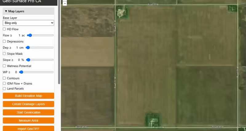
🗺️ Build Detailed Elevation Maps in Seconds
In LiDAR-covered areas, simply draw a boundary around your area of interest and click Build Elevation Map. Geo-Surface will generate a high-definition, colorized 3D terrain overlay that lets you see slopes, ridges, and depressions with stunning clarity. Perfect for:
-
Visualizing farm fields and terrain
-
Identifying drainage issues
-
Scouting elevation changes before planning tile or surface drainage
-
Creating terrain references for crop zones, development, or conservation
🌐 100% Browser-Based — No Software Required
Geo-Surface Canada runs right in your web browser on any device. Whether you’re on a laptop in the office or a tablet in the field, you can explore and export Canadian elevation data with no installs, no logins, and no cost.
-
✅ Click-to-view Canadian elevation
-
✅ Generate elevation overlays from LiDAR
-
✅ Measure areas in acres
-
✅ Export maps for reports or reference
-
✅ Works on desktop, tablet, or phone
💡 Want to Go Further? Unlock Geo-Surface Pro
Need to model water flow, identify drainage paths, or design your own surface or tile drainage system? Geo-Surface Pro adds professional-grade features including flow mapping, slope and wetness analysis, and full drainage design tools—still fully web-based.
🎯 Perfect For:
-
Farmers planning field drainage
-
Consultants analyzing elevation and slope
-
Landowners checking terrain for development
-
Conservation teams mapping topography and runoff
-
Anyone who wants fast, free access to Canadian elevation data
🔍 Try the Free Canadian Elevation Viewer Now
Just click on the map to explore your land’s elevation in seconds.
No signup. No software. Just powerful elevation mapping—free.
Disclaimer and License
This tool is provided solely for informational and educational purposes and does not imply any license, right, or permission to build, operate, or maintain water control works or any other engineering installations. It is not a substitute for professional judgment, legal counsel, licensed land surveying, or properly qualified geospatial engineering services. The developer makes no warranties, express or implied, regarding the accuracy, completeness, fitness for a particular purpose, or reliability of any data, results, or information produced by this tool.
By accessing and using this tool, you acknowledge and agree that:
- You assume full responsibility for any decisions, actions, or outcomes arising from its use. This includes verifying compliance with all applicable local, regional, or national laws, regulations, and permitting requirements.
- The developer shall not be held liable for any errors, omissions, inaccuracies, or any direct, indirect, incidental, consequential, special, or exemplary damages resulting from the application of information provided by the tool.
- You will consult with licensed professionals, such as qualified surveyors, engineers, and legal advisors, for site-specific guidance, and will not rely on the tool as definitive or authoritative.
- Use of the tool is not guaranteed to be uninterrupted or error-free. Functionality may be limited or unavailable due to server outages, internet connectivity issues, third-party data provider problems, or high usage loads. You acknowledge that such interruptions or service reductions are beyond the developer’s control and agree that the developer assumes no liability or obligation to provide uninterrupted service or refunds.
- Your access and use of this tool constitutes a full and final waiver of all claims, known or unknown, present or future, against the developer arising from or relating to the tool’s use, functionality, or any data derived therefrom.
- If you do not agree with any part of this disclaimer, you must discontinue use of the tool immediately.
- You acknowledge that any information provided by this tool is used at your own risk and is offered “as is” without warranties of any kind, including but not limited to warranties of merchantability or fitness for a particular purpose, to the fullest extent permissible by law.
- You further acknowledge that no professional-client relationship (including engineering, surveying, or attorney-client) is established by the use of this tool or any information derived from it.
License Terms
This tool and its associated data, code, and materials (the “Licensed Materials”) are licensed for use only in accordance with the terms of the license purchased by the user. Different license types may carry specific restrictions regarding usage, number of authorized users, permitted applications, and geographic scope of use. You must at all times remain in full compliance with the terms of the license that you have purchased. Unauthorized use, sharing, or distribution beyond the scope defined in your purchased license is strictly prohibited.
© 2025 GIS4Ag. All rights reserved. Any copying, modification, reverse engineering, redistribution, or use not explicitly authorized by the purchased license is strictly prohibited. Violations may result in immediate termination of the license and potential legal action.
Governing Law & Severability
This Disclaimer and any disputes arising from the use of this tool shall be governed by and construed in accordance with the laws of the jurisdiction of Manitoba. You agree to submit to the exclusive jurisdiction of the courts of that jurisdiction for the resolution of any disputes.
If any portion of this Disclaimer is found to be invalid or unenforceable by a court of competent jurisdiction, the remaining provisions shall remain in full force and effect.
Last Updated: April 2025